Barra to the Butt; The Outer Hebrides
In May of 2011, I crammed my bike bag with camping gear, panniers and bike and flew out of Australia heading for the Outer Hebrides, a string of rocky islands lying nearly 80km off the north western coast of Great Britain. These islands stretch from Barra in the south to the Butt of Lewis in the north - just a small chain of rocky hummocks, remote, isolated and so completely different to any other place I have ever visited. From their western coastline only the small islands of St Kilda and Rockall separate the Outer Hebrides from the vast Atlantic Ocean and the waves that roll onto the eastern seaboard of the United States.
There are two distinct sides to this island chain. The eastern side is characterised by mountains, a lunar rocky landscape dotted with small fishing hamlets crouched at the head of narrow lochs within the deeply indented and jagged coastline. In stark contrast the western coastline boasts broad bands of silver-white sand beaches unbroken for miles and lapped by the tortoise coloured sea of the Atlantic. These diverse islands were my home for the next few weeks as I cycled the length of them from South to North.
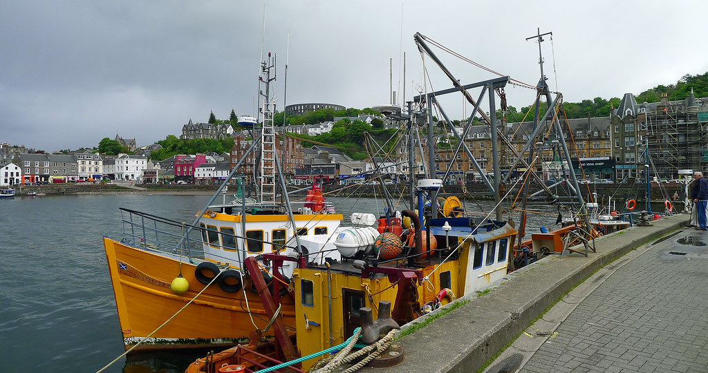
Three flights, a couple of taxis, a train from Glasgow to Oban and nearly forty hours after leaving Brisbane I arrived in Oban, a little seaside town on the Scottish west coast that is the gateway to the Hebredian Islands. I spent two nights in Oban assembling the bike, packing, purchasing supplies and sight seeing around the town. Late afternoon on the third day in Oban I stowed my bike under threatening skies on the car deck of the Caledonian MacBrayne ferry, and set out on the crossing to the Isle of Barra.

A Voyage West.
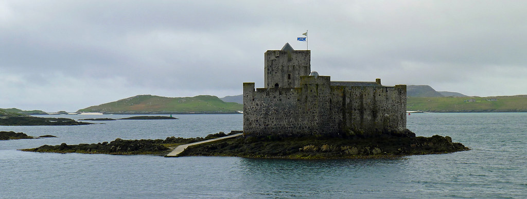
Once out of the protection of the inner islands the sea turned lumpy and the crossing became uncomfortable. Five hours into the voyage I caught a glimpse of the Hebrides rising out of the vast Atlantic, highlighted by the glow of the setting sun as it dipped towards the horizon. The shimmering glow it cast over the sea illuminated a path which guided our entry into the natural harbour of Castlebay. As the ferry slid into Castlebays late evening twilight, I rejoined about a dozen other cyclists on the car deck eagerly waiting the lowering of the bow door and my first steps onto the islands. I wheeled the bike the short distance to the Craigard Hotel, unloaded and enjoyed a late dinner in the dining room which overlooked Castlebay and the castle that guards the harbour.
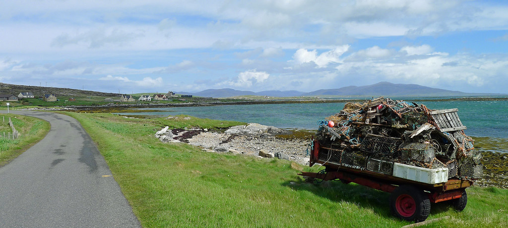
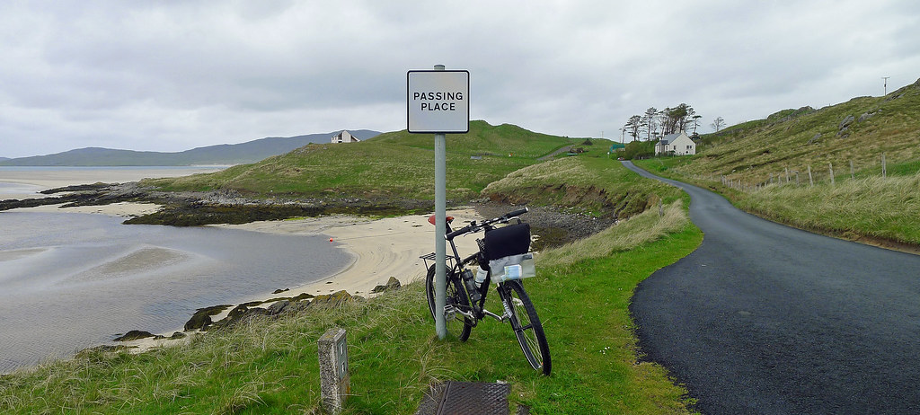
The next morning the weather had taken a turn for the worse, a theme that was to continue for the rest of my time in the Western Isles. I made arrangements to stay two nights in a B&B, dropped my gear there and set out on a circular route around the island. Cycling anticlockwise out of Castlebay there was a long steep climb that provided great views back to Castlebay before I enjoyed the fast descent towards the eastern shores of the island that were home to isolated fishing villages and rocky shorelines.
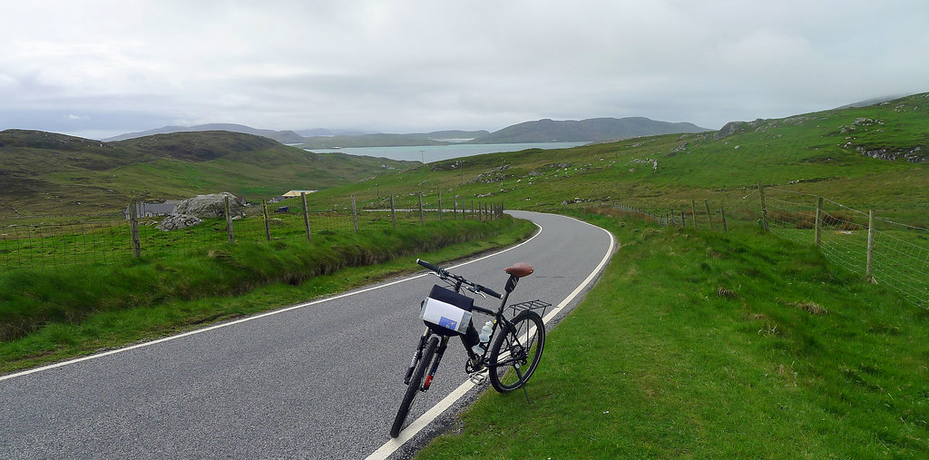
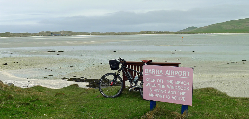
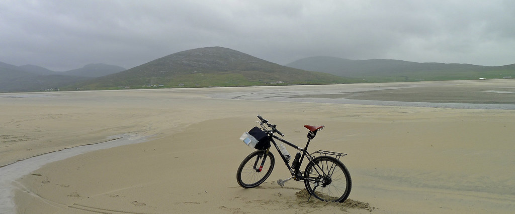
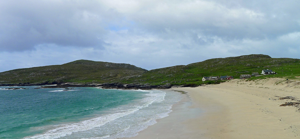
About half way around the island I took the turn off for Traigh Mhor, where a huge sandy bay housed the Barra airport terminal, cafe and beach runway. Sadly, as it was Sunday the airport cafe was closed so I couldn't indulge in the soup or cake I had read about on the internet before leaving home. Pedalling on I followed the western coastline with its beautiful sandy beaches before returning to Castlebay for the night.
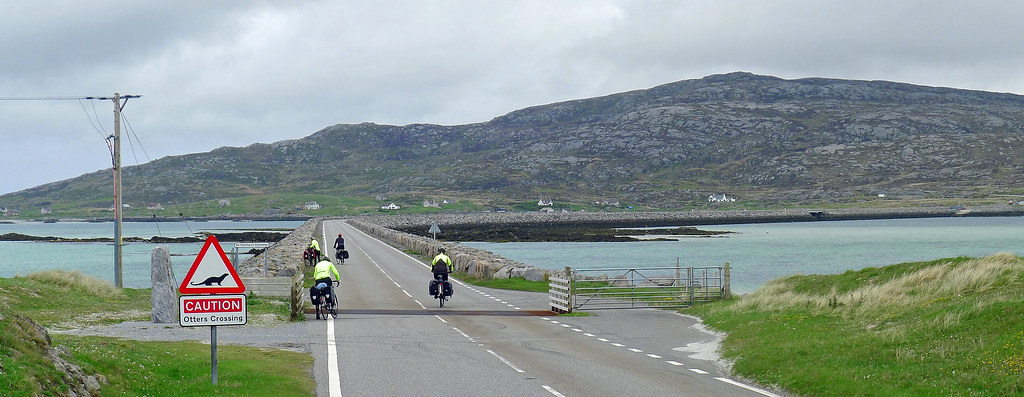
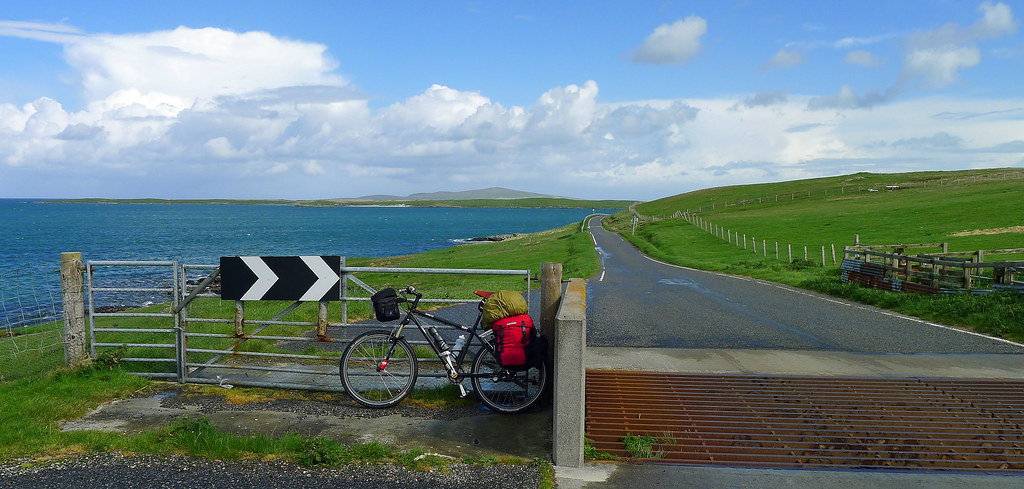
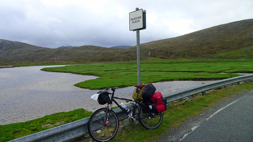
The next morning the weather was appalling, cloudy, windy and driving rain. I wasn't happy with my front brakes at all; they felt spongy and grabbed at the rim intermittently which made for some uncomfortable and downright dangerous braking on such a heavily loaded bike. I had noticed a bike repair and rental shed just outside of the village so I rode around and had the old man managing the shopfront take a look. A half hour later he had the brakes feeling better than when the bike was new so once more I was raring to go. Despite the weather, I pressed on, climbing another brute of a hill outside of Castlebay that led to the causeway that linked the island of Barra and the small southerly island of Vatersay.
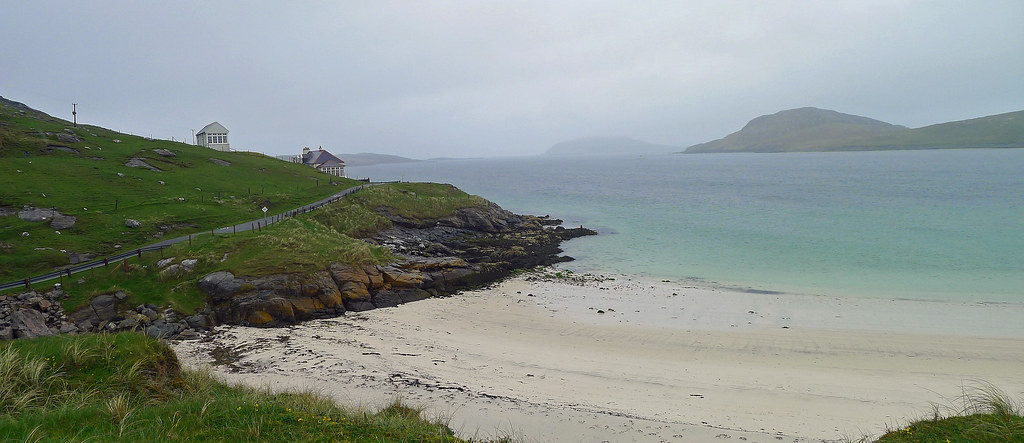
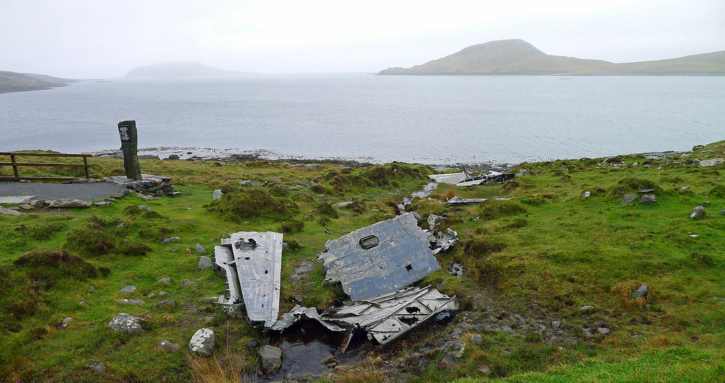
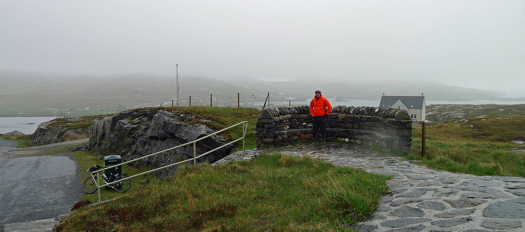
I followed the narrow single track road around the island to the beautiful golden beaches and turquoise waters that line Vatersay bay. For such a beautiful island, Vatersay has been marked more than once by tragedy: and the signs are still visible. A memorial and a cairn of rocks above West Bay marks the burial site of 350 men women and children whose bodies were washed ashore here on 28 September 1853 when the three masted sailing ship the Annie Jane was wrecked in a storm. And between the shoreline and the road as it skirts the north side of Vatersay Bay, the very obvious wreckage of an aircraft lays scattered amongst the heather. This is all that remains of an RAF Catalina flying boat, which crashed higher up the hillside on 12 May 1944 during a training flight from Oban. Three of the nine men on board were killed. As I surveyed what was left of the wreckage, I was surprised that anyone at all had survived the impact. Extremely cold and a little wet from the ride I retraced my route back to the B&B for a hot shower and later that evening I rode into Castlebay for dinner at the famous Cafe Kismul.
An Infamous Island
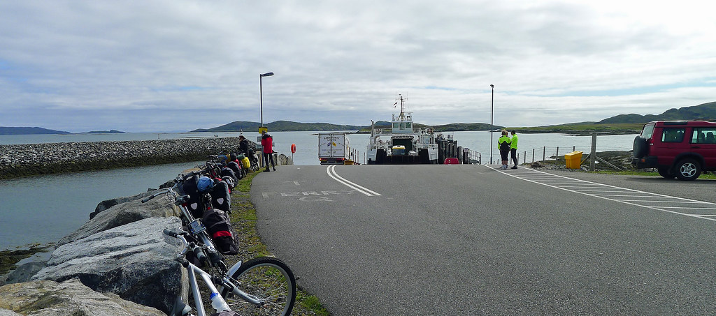
The next morning I packed the bike and pedalled around to the islands ferry terminal at Aird Mhòr. From there I hoped to catch the first ferry to the small island of Eriskay which is connected to the northerly island of South Uist by a causeway. I planned to make a few ferry crossings during my cycle tour of the Hebrides, so I had purchased ‘island hopscotch’ tickets, which are a good flexible and economic way of getting between the islands. Departing the B&B I met a Scottish couple leaving for the same ferry so we cycled the route together. I was glad of the company as I was unsure how long it would take me to get around to the ferry and they provided a helpful ‘tow’ that saw us at the terminal with plenty of time to spare. Boarding the small ferry, we leant our bikes precariously against the ferry’s rail, which made me a little nervous as I envisaged my heavily laden bike toppling over during the crossing.
A little concerned, I crept off to the outside passenger deck seeking shelter from the bitter wind, perched myself beside an outlet that was blowing hot air and enjoyed the seascape rolling by and Barra disappearing into the distance. Forty minutes later, I came alongside the pier at Eriskay and was soon back in the saddle and pedalling up the short, steep, severe incline that rose away from the landing slip. Eriskay was less than three miles in length and roughly half that in width so my stay on the island was short and sweet as it only took a little time to pedal over to the causeway that stretched across the Caloas Eiriosgaigh or Sound of Eriskay. Still, time enough to reflect on famous events in this tiny island’s history.
Not far from the ferry landing port on August 2nd 1745, Bonnie Prince Charlie and his Seven Men of Moidart landed from the frigate Du Teillay en route to stage the ill-starred Forty-Five Jacobite Rebellion. Eriskay is also infamous as the site of the shipwreck that inspired Compton Mackenzie’s novel Whisky Galore! In 1941, the S.S. Politician ran aground off the island when bound for New York and a group of islanders raided the wreck for its consignment of 24,000 cases of whisky.
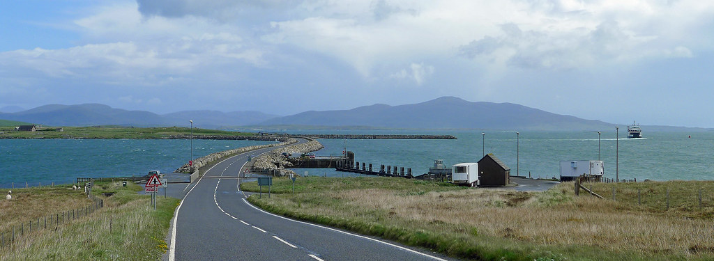
I arrived at the causeway, which is just over a mile long, and without a drop of whiskey in sight, pedalled across to South Uist as the wind and rain became more forceful. It was a lonely ride along the south coast for a few miles before I turned north along the road that cleaves to the low-lying terrain on the island’s western side and forms the spine through South Uist. In good conditions this single track road would make for easy cycling, but as I continued north, past the turning for Lochboisdale, the island’s main settlement and mainland ferry port, the wind and rain slipped up another notch. I was feeling quite exposed in the flat treeless landscape and copped a severe pummelling from the wind so I was happy that the accommodation I had booked in Daliburgh beckoned in the near distance.
Unexpected Delays on the Uists.
My accommodation, the family run Borrodale Hotel lay on the main North, South road that runs the length of South Uist. The Hotel was a short walk from the sandy shore of the Atlantic coast, which was backed by low-lying machair dunes that are prominent on the Uists and within walking distance of the small Daliburgh village. After settling in, getting warm, then discovering the appalling weather conditions for the next few days I arranged further night’s accommodation with the Hotel before tucking into a meal in the Hotels main bar.
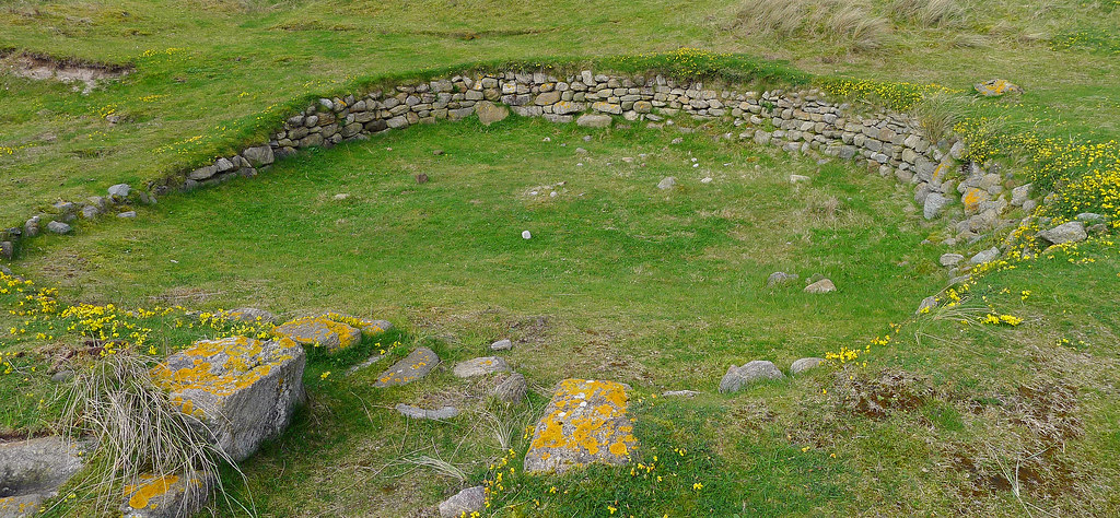
I spent the next few nights in Daliburgh, during the day walking to the little village then out to the dunes and the Atlantic coast. I discovered the machair hid the remains of the Prehistoric Village of Cladh Hallan with its collection of round houses dating back to 1000 BC. I was fascinated by this site as it had unearthed dwellings, middens, artefacts and burial grounds underneath some of the round houses. In fact some of the bodies which included a 12 year old and 3 month year old child had shown signs of mummification however, the methods employed were far less sophisticated than those practiced in Ancient Egypt. Not far from these burial grounds I explored the modern cemetery of Cladh Hallan which sat perched atop a rise overlooking the wild Atlantic and to the east a vast, low-lying landscape of bog, fragmented by innumerable lochs and lochans of South Uist. The bleak scene before my eyes bore testament to the harsh environment that was made ever more evident by the aging tombstones that bore witness to many a young life cut short on these isolated islands in times long gone.
The next day high winds and rains were forecast so I contacted the local bus company to arrange a lift through South Uist, Benbeeculla and onto the ferry port at North Uist. In fine weather I would have ridden this route but in reality the Uists and Benbeculla are by far the least attractive of the Outer Hebridean Islands, so I was not disappointed to miss cycling this section. The route tended to be exposed and flat with minimal views as the road up the spine is bordered by the machair and low lying land lochs. Now despite the claims on the internet and the tourist information publications that any of the bus companies will be happy to take your bike on board it is simply not that easy. In fact, I get the feeling its more about good luck than good management as these days some of the transport companies outright refuse to carry bikes. I took the precautions of phoning the bus company, confirming that I had a bike, explaining that I had booked accommodation at my destination for that day, and that if required I was happy to dismantle the bike. The office was very helpful and reassured me they would take me onboard and no need to dismantle the bike as the bus they were using that day had a baggage hold. Great, all sorted, or so I thought!
The next day I was at the appointed bus stop at the appointed time when the bus rolled up and seemingly reluctantly, stopped. Out jumped a young female driver looking distastefully at the bike claiming she couldn’t really take bikes on the bus. I pointed out that I had phoned her company’s office and they had assured me they could carry my bike fully assembled. She then claimed they had changed the bus they usually run on this route and this bus had no baggage hold. I stood my ground and eventually she somewhat uncooperatively agreed to open the rear doors and allowed me to hoist the bike over the back seats to rest on them. A very tight fit! Then somewhat caustically she stated that if the bus filled up I would have to get off and cycle the rest of the journey. Fat chance of that I mumbled to myself. Anyway, the bus never came close to being full and the majority of the journey was spent with the driver driving one handed at a fair clip while chatting the whole time in Gaelic to an old local occupying the front seat.
Now I had discussed my destination with the transport office and had purchased a ticket from the driver to Lochmaddy on the north eastern end of North Uist which was my destination for the evening. However, a few miles out of Clachan na Luib the driver told informed me the bus terminated there did not continue onto Lochmaddy. At this point I was the only passenger left on the bus, so I queried as to why this was the case and received some vague response. In the end I decided not to argue the point and just deal with having to load the bike up and ride the roughly 20kms into the wind and rain towards Lochmaddy. Sufficient to say it was a cold and uncomfortable ride. Looking back I think I was conned. I was the last passenger on the bus, there are no official stops between Clachan na Luib and Lochmaddy, so the driver probably had no passengers to pick up and decided she didn’t want to drive the 40km return trip onto Lochmaddy. Her only saving grace was that she shared some home cooked fudge with me that had been given to her by the local occupying the front seat. Maybe I’m being a bit harsh but it was the only time on the trip that I felt like I was being screwed and taken advantage of because I was a tourist.
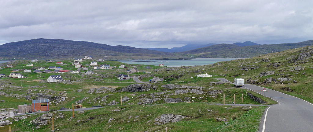
Leaving Clachan na Luib where there are a few houses a shop and Post Office I struck out in a north-easterly direction toward Lochmaddy. I soon passed the Neolithic chambered cairn of Barpa Langass on the flank of Beinn Langais which is a small dome-shaped hill standing out amid a vast landscape of bog, dotted with countless lochs and lochans. I pedalled across the bog into a vicious headwind for half an hour or so, until I reached Sruth Morn, here I turned north-east, and continued on a short distance into Lochmaddy. My accommodation for the night was Redburn House B&B in Lochmaddy. I was fooled by the exterior, it looked like an old run down two storey hostel however, it boasted an exceptionally clean and modern interior. The owner lives off site and there were no guests so I had the entire house to myself. Breakfast was left in the fridge for the morning and I had the run of the modern kitchen to cook dinner that night rather than eating out. Braving the bitter cold wind I strolled down to the Lochmaddy ferry terminus for a look around before hurrying back to Redburn House to warm up. It was a little spooky that night with the wild wind and driving rain making the empty old house creak and groan however, I slept well.
Dodging Hailstones.
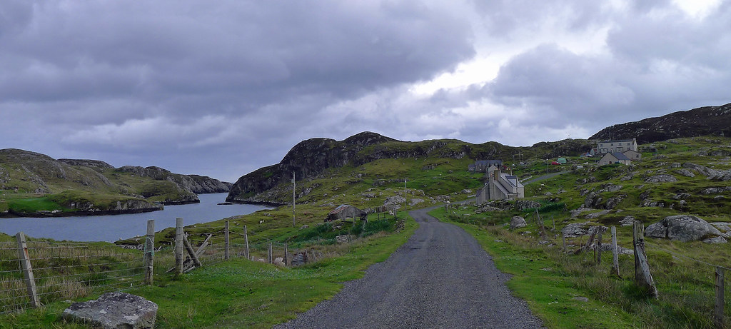
Wild and windy weather is what greeted me when I poked my head out the front door the next morning. Despite the temptation to linger in the warmth of the B&B I headed out, cycling in a north-westerly direction, away from Lochmaddy towards the tiny island of Berneray, my destination for the evening. Leaving Lochmaddy the terrain changed and the road became more up and down, which made for more interesting cycling. However, the wind increased and while I was generally in a cross wind the road occasionally turned into the wind and despite my best efforts forward momentum became limited. To make conditions worse some low, dark clouds rolled in from the west bringing driving rain that sand blasted my face. Hail storms accompanied the rain, slamming hail the size of peas into my helmet and face with uncomfortable force. Three times in the next hour these passing hail storms tormented me before the weather eased slightly as I turned of the A865 in a north-easterly direction towards the cause-way that links North Uist and Beneray.
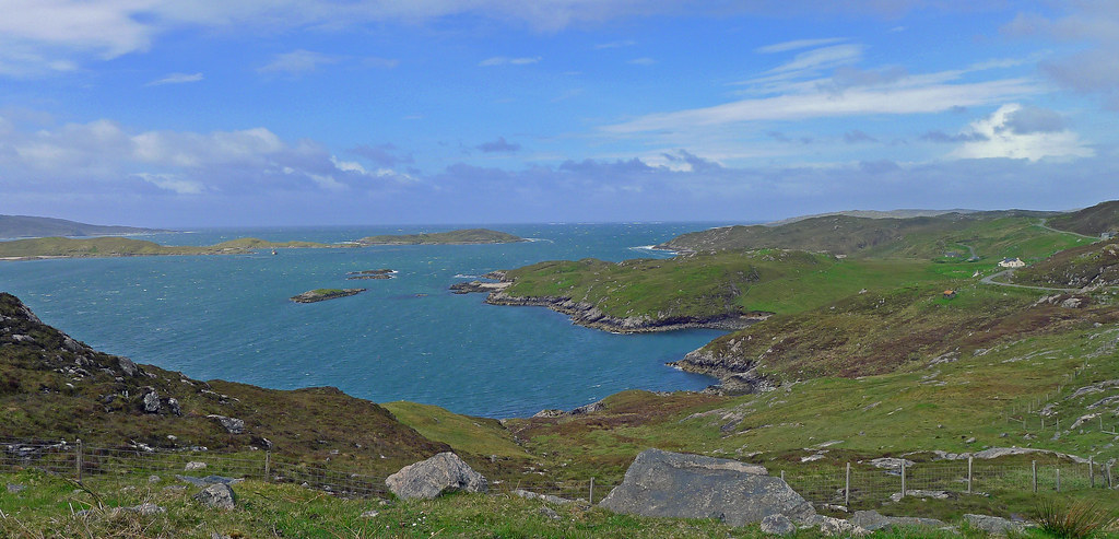
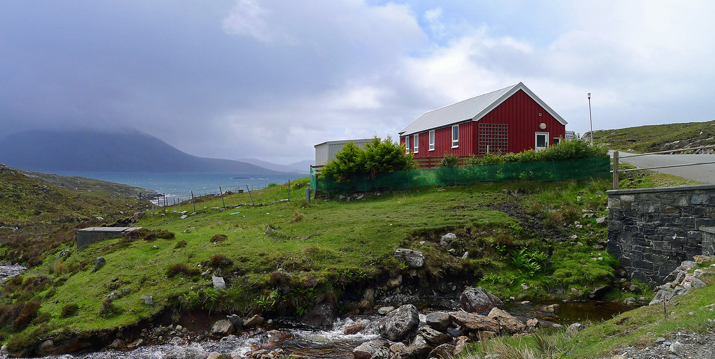
Pedaling along the foot of Beinn Mhor, I passed Dun an Sticir. This site linked by an artificial causeway was originally a circular and galleried fort dating from perhaps 1000 BC. The structure is located on an island in Loch an Sticir and in medieval times a house was built inside the ruined fort. With the sky clearing to blue but the wind continuing unabated the road descended slightly into the Port nan Long peninsula. Here, set against the backdrop of Beinn Mhor and Beinn Bhreac I was surrounded by white sandy beaches and the deep blue waters of the Caolas a' Mhorain Strait and Atlantic Ocean. Soon, I was on the causeway, my objective, the Beneray Hostel almost in sight. The last couple of miles of road before the hostel followed the coast through the village of Borve (or Borgh in Gaelic) and around two natural harbours. I turned down the last stretch of road and soon arrived at the hostel perched on the beach overlooking the Sound of Harris, bordered in a meadow and accompanied pleasantly by grazing sheep.
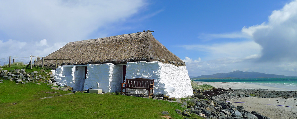
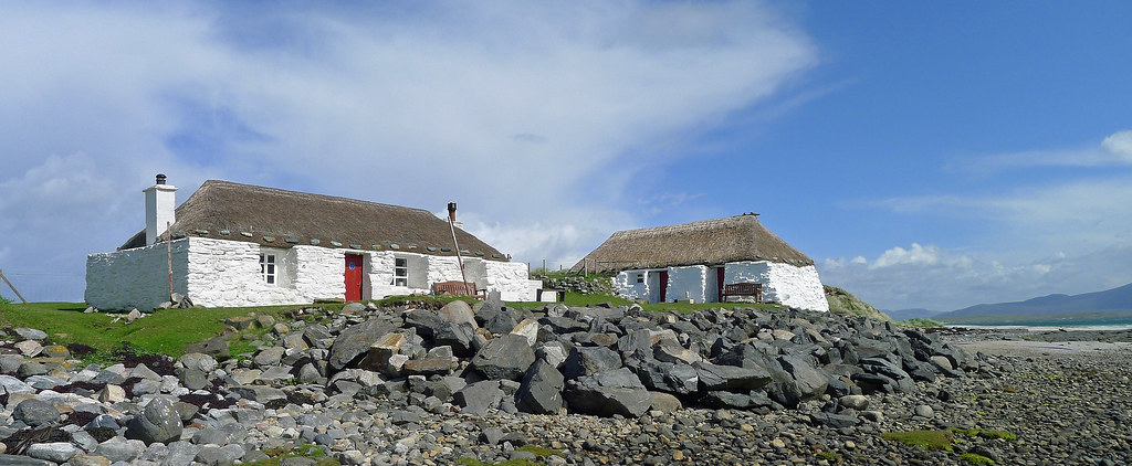
The hostel itself was two old ‘black house’, that are a type of thatched roofed crofters’ cottage characteristic of the Outer Hebrides and so-called because of the often sooty interiors caused by the lack of a chimney; smoke would escape through the thatched roof. In common with the Gatliff Trust’s three other hostels in the Outer Hebrides, Berneray has simple, but adequate facilities. The Hostel comprises two thatch cottages, one containing two bunkhouse bedrooms, bathroom and toilet, the other dining and kitchen facilities and another bunkhouse bedroom. There were minimal guests when I arrived so I deposited my belongings in the front bedroom of the bunkhouse in the quaintly named ‘The Honeymoon Suite’. Sparsely furnished with two double bunks I claimed the only single bunk with a window view hat overlooked the golden beach of the Sound of Harris.
Initially the afternoon was blessed with blue skies but the wind increased in strength as the afternoon lengthened. Walking back to the village café I was caught in another hailstorm and had to seek shelter behind a delivery van from the driving hail. After a quick lunch I returned hastily to the hostel where the wind had stirred the waters of the Sound of Harris from a relatively benign state into a sea of white caps and standing waves. Hunkering down in the hostel I witnessed another passing storm carpet the grounds outside in a bed of hailstones.
Late evening, and the hostel was full by this time. The dining room hummed to the sounds of a diverse group of people on a variety of different journeys, cooking, chatting and hanging there soaking clothes out to dry. An eccentric old German guy and his poor long suffering wife provided the evenings entertainment but more importantly he proved his mettle by eventually lighting a roaring fire in the fireplace. Communal accommodation has never been to my liking but I had to admit that the atmosphere was cheerful and friendly and the evening passed quickly enough. After dinner, a cup of hot chocolate, a chat with a few of my fellow travelers, I payed the hostels warden the grand sum of six pounds for the night, and headed off to bed. I now shared the bunkhouse with four other elderly cyclists, one a rather loud snorer which together with a lumpy mattress made for a fitful nights sleep.
A Treacherous Crossing.
Next morning after electing to skip breakfast I hurriedly packed the bike in the driving wind and rain that greeted me when I poked my head out of the hostel door. It was only a short ride back to the terminal for the 10:30am ferry but it was made all the more arduous by the appalling conditions. Thankfully, the terminus maintained a shelter which allowed me to regain some warmth while waiting for the ferry but, it was still bitterly cold.
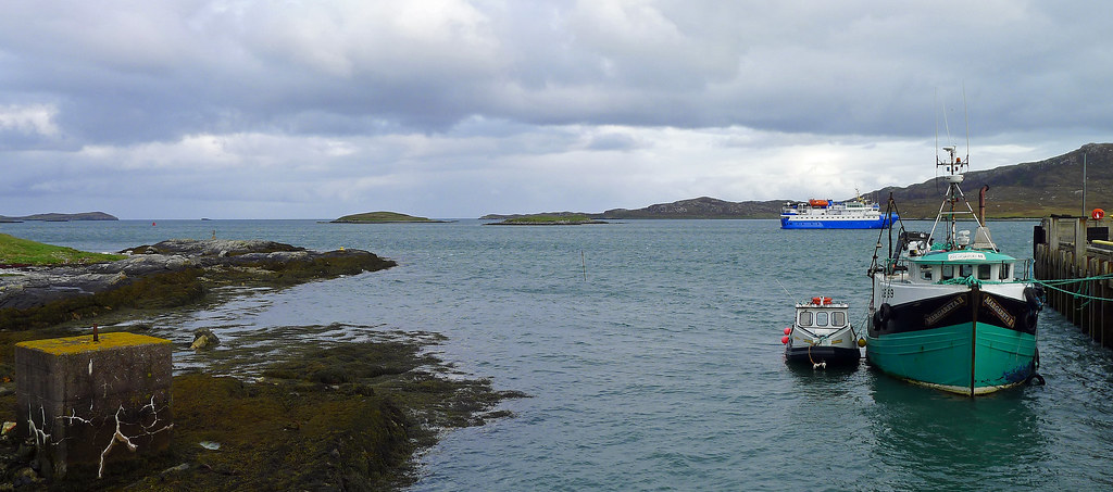
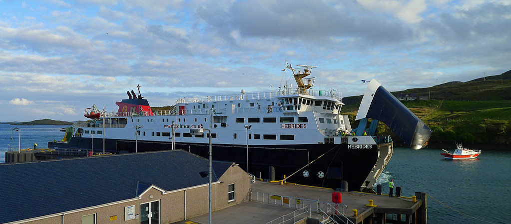
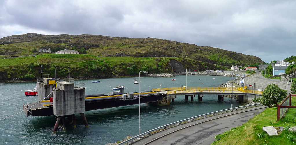
The shallow and treacherous Sound of Harris may only be a relatively short distance from Berneray to Harris but the ferry crossing involved some spectacular course changes during the voyage. The Sound of Harris is notoriously shallow and some of its more dangerous features include sandbanks and rocky reefs. Battling fierce winds and a little over an hour later the ferry ‘Loch Portai’ safely deposited me on the slipway at Leverburgh, a small ferry port on the southern extremity of the Isle of Harris.
After a short but agonisingly slow cycle into the horrendous wind I arrived at my destination, a B&B overlooking the Sound of Harris on a lonely stretch of headland. I holed up there for the rest of the day, sheltering from the conditions,keeping warm and only venturing out that afternoon for a stroll during an all to brief break in the weather. That night I dined in the restaurant by the ferry slipway (best lasagne I have ever tasted) before retiring for the night.
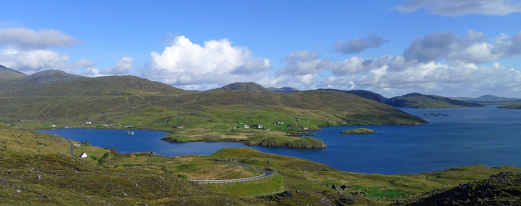
The next mooring after what can only be described as an ‘interesting’ night at the B&B I cycled away heading for Tarbert the ‘hub’ of Harris, not that there is much competition on this dramatic island of mountains and beaches. During the 40km ride that morning and the following week I fell under the spell of the Isle of Harris. In actual fact Harris is not an island as North Harris is connected and bordered by Lewis in the north while south Harris is almost a separate island with the town of Tarbert as the centre.
An Isle of Contrasts.
Harris is a land of contrasts; the north which is sparsely populated contains Clisham (An Cliseam), the highest mountain in the Outer Hebrides at 799 metres. The southern part is less mountainous and the south-western coastline is home to numerous unspoiled white sandy beaches. Of all the beaches on South Harris Luskentyre and Scarista are the most spectacular. This scenery lays claim to being some of the most breathtakingly beautiful in the Western Isles and in fact in the whole of Scotland, a claim I fully support.
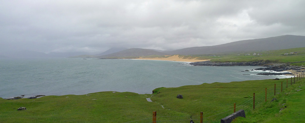
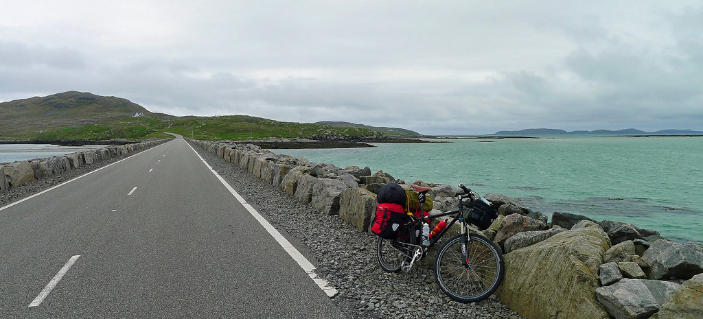
Leaving Leverburugh I followed the A859, heading north-west. Almost immediately the introduction of a few inclines slowed my pace however, the west coast road is more undulating than hilly with only one significant climb on its serpentine course towards Harris and my destination for the night at Tarbert. This route provided a dramatic change in the scenery as I had left behind the low lying lands of the Uists and entered a landscape of rugged hill country fringed with vast stretches of golden beaches and turquoise waters. Offshore a sprinkling of islands dotted the horizon including the Isle of Taransay just a mile across the sound to the west which, in 2000, was the location for the BBC-TV reality series, Castaway. My progress was slow as numerous times I stopped pedaling, transfixed by the beauty of the landscape, bewildered and pleased that somewhere so beautiful remains so relatively unspoiled.
The road west snakes through the machair alongside a vast stretch of shell sand beach known as Scarista Beach. Rising and falling above the golden beaches the road swept me passed past offshore islands and crashing waves before turning east and beginning a long, steep but steady climb of about 5kms. Here the landscape changed to one of lunar type rocks, lochs, running streams and misty mountains. After the climb it was a long downhill ride into Tarbert which is a natural harbour perched within the loch of Tarbert or Tairbert in the Gaelic language. About 6kms out of Tarbert the weather blew in furiously and the winds rose to gale force. The wind was blowing from my left hand side, at times sending me careering across the road at 45 degrees towards oncoming traffic. I sheltered in a bus shelter for nearly an hour but the wind did not abate significantly so I made a dash into the wind and cycled the few remaining kilometers into Tarbert.
It was still early, around midday and I was staying at the Hebrides Hotel; a boutique hotel recently renovated and overlooking the jetty and pier in Tarbert. Fortunately the room was available early so I booked in and had a hot shower as the wind had chilled me to the bone. I ordered room service, and relaxed watching the Tarbert/Isle of Skye ferry glide into the pier a stones throw out of my window.
At the time I didn’t realise it but Harris and in particular Tarbert was to become my home for the remainder of my stay in the Isle’s. The wild weather he Western Isles experienced over the following week played a large part in this but in truth I had fallen in love with this island almost immediately. I loved its contrasts, quietness, isolation and the ample space to explore. The stunning beaches lapped by turquoise waters set against a backdrop of brooding mountains; the ever changing skies; the hamlets and miniature fjords; the lunar rock of the east coast that shone in the sunlight; the lochs and inlets that are home to basking seals; the astonishing array of birdlife; all this, had found a captive audience in me over the course of the following days.
A Word on the Weather.
It has become an all too common theme in this post but a final word on the weather experienced during my times in the Isle’s. I selected this time of year to travel as it is ‘normally’ the best time of year sadly, this was not to be. Even the locals remarked on the unseasonal weather. Essentially it started raining the day I arrived on the islands and was still raining when I left. While the rain was manageable the wind was horrendous, with gusts over 100km/hr. Their force ensured the occasionally power failure in the accommodation I was staying in, together with traffic accidents that closed some of the roads for hours on end rendering travel between islands impossible.
The Western Isles did not suffer alone; the rest of Britain went on amber alert for damaging winds on a number of days as well. Mercifully, most of my cycling was done with a tail wind but the times I experienced a cross or a head wind it was not only dangerous (thankfully only light traffic) but soul destroying. As well, the weather destroyed my hopes of enjoying Scotland’s wild camping laws with the plan being to wild camp on most nights during my stay. In the end I carried camping gear all the way from Australia to Scotland without spending a night in a tent. Instead, I enjoyed the comforts of credit card touring! To add further insult towards the end of the trip the ash cloud from Grimvotn, the erupting Icelandic volcano, came close to throwing my departure plans from the United Kingdom in disarray but, a change of wind direction saved the day. So that’s my final whinge on the weather for this post. The reality was that while occasionally annoying, the extreme weather conditions framed the landscape in a menacing yet dramatic perspective, the like of which I may not have experienced in clement weather.
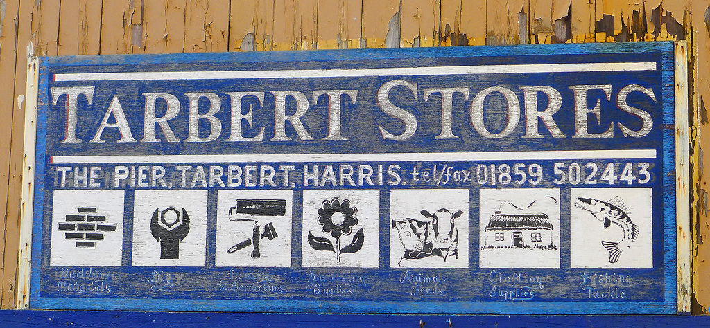
The village of Tarbert ended up being the perfect base for exploring the rest of the Hebrides during the remaining week or so I had left on the islands. The village is home to two hotels, a tourist information point, a tearoom, bank, a Harris Tweed shop and the ferry port for onward travel to Skye. Excluding Stornoway on Lewis it is a bustling little town by Hebredian standards and takes its name from the Norse ‘Tairbeart’ meaning drawboat. The significance of this is obvious considering Tarbert lies on the shores of Loch Tarbert and South Harris and only narrowly avoids becoming an island by just a few hundred yards of land. Here, the Vikings would drag there ‘draw’ or long boats over the small strip of land to Loch Tarbert, creating a shortcut that would avoid the long sail around the Sound of Harris.
The Golden Road.
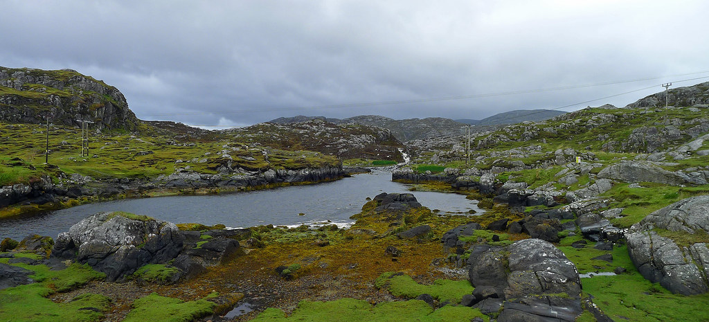
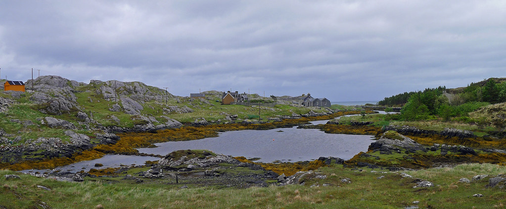
Leaving Tarbert one morning I traveled down the Golden Road that winds and twist its way down the east coast of Harris which is occasionally called The Bays, an apt description because of its miniature fjords. The Golden Road took it name from the locals who were of the opinion that the expense of building the road was so great that it must have been made of gold. On its path towards South Harris it connects all the rugged and seemingly inhospitable hamlets, once only accessible by sea, whose names being of either Viking or Gaelic extraction, defied pronunciation by my English speaking tongue. The scenery was spectacular almost ‘lunar’ like as I have mentioned before and the poor weather conditions added menace to the landscape and provided an air of trepidation. This region, deeply indented by lochs, provided some of the rockiest low level scenery anywhere in Scotland with gray rock being the predominant colour only occasionally relieved by patches of green.
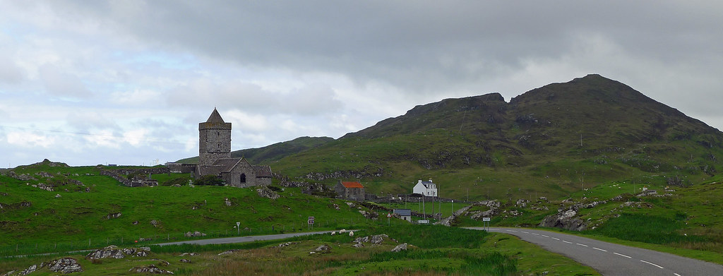
The Golden Rd eventually deposited me in the small village of Rodel, home to the Church of St Clements and the inspiration for many a postcard. The Church, built in the 15th century for the Chiefs of the Macleods of Harris is the most elaborate surviving medieval church on the Outer Hebrides. Three miles down the road I arrived in Leverburugh my previous home for the first night I spent on Harris. From Leverburgh I rejoined the road I had cycled previously up the west coat and once more enjoyed the wide beaches of sand lapped by the waters of the Atlantic and buffeted by its severe winds. Leaving Leverburgh behind I traveled alongside the Tràigh Losgaintir in the Luskentyre estuary, past the turnoff to Losgaintir Beach which I would visit the next day, back towards Tarbert.
The Bridge to Scalpay
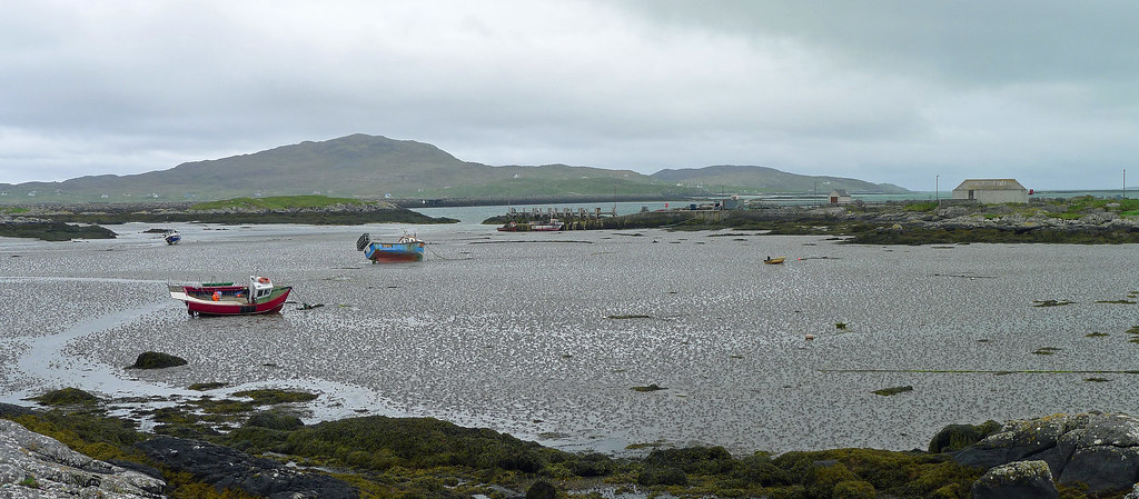
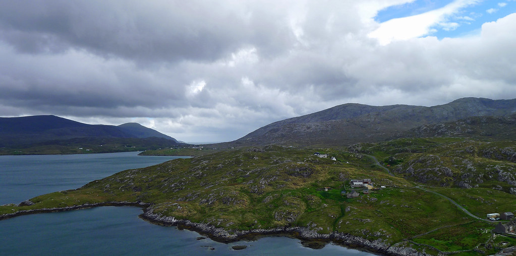
Passing through Tarbert I traveled the few miles to the Isle of Scalpay. Scalpay is a small island measuring only 2 miles long and 1 mile wide and prior to 1997 was only accessible by ferry. Today I made the crossing from Harris via a modern bridge that not only seemed out of character for the Outer Hebrides but its mere presence seemed unfathomable considering the islands dwindling population and the closure of most of islands services. That said, the island has its own rugged charm, peppered as it is with small lochans and home to an aging fishing fleet which I found moored in the rocky north harbour. Further east on a tiny peninsula I discovered the Elian Glas Lighthouse, one of the first lighthouses ever to be built in Scotland and still standing, tall and resplendent in its distinctive white and red paint scheme.
The Best Beach in Britain.
The next day I retraced my route down the west coast of Harris towards Tràigh Losgaintir in the Luskentyre estuary. At the head of the estuary I cycled north-west along the single track road that skirts the north side of Luskentyre and is home to the sparse settlement that lay scattered along it course. I cycled past a few farmyards, the occasional holiday home, two lonely graveyards and sand, miles of it.
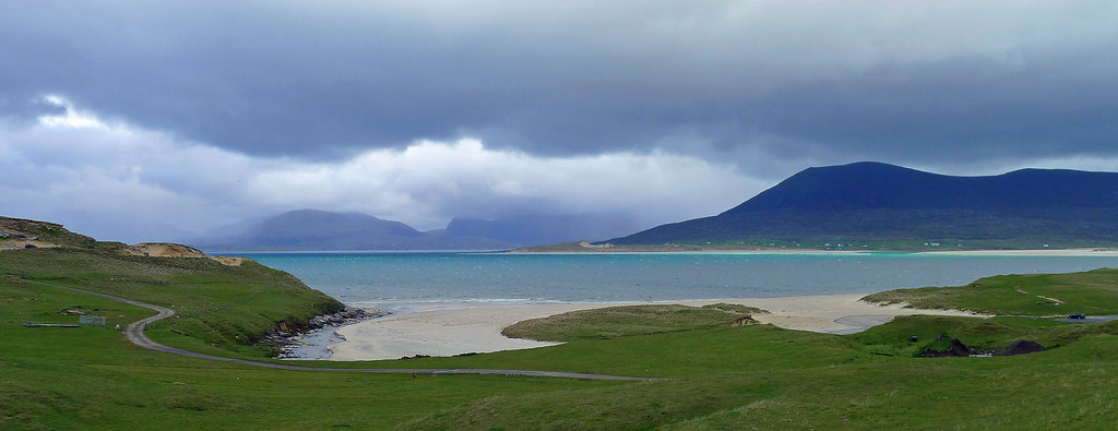
It was pleasant cycling as I followed the winding road around the stunning Luskentyre Bay which provided me with my first ‘taste’ of Losgamstir Beach. Continuing northward I passed some truly vast sand dunes that at times obscured my views of the beach, before the road ended in a small car park. Here, it was possibly to walk between the dunes to Tràigh Rosamol another beautiful beach that faces north-west towards the island of Taransay and the mountains of North Harris.
This was coastal scenery at its best, and what scenery: with the stunning blues and turquoises of the sea set against the near whites of the beaches tufted with marram grass, the different hues of the sky, the greens of the grass and the greys of the rocks. It was no wonder this beach had been voted the best beach in Britain. Despite my visit being dampened with rain, overcast skies and wind, it was not difficult to imagine that on a fine day this beach and scenery would rival the best any Caribbean beach could offer. After a brief photo opportunity on the beach I retraced my route once more back to Tarbert.
The Road to Huisnis
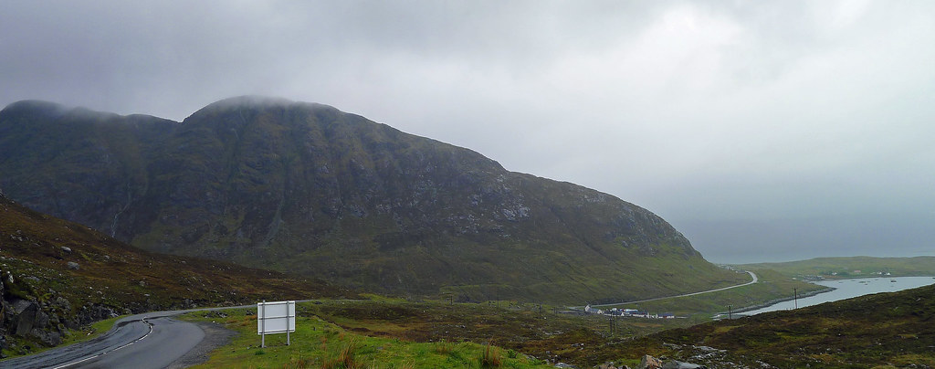
The next day I travelled a few miles north from Tarbert to a junction signposted west to Huisinis on the B887. This single track road that follows the south coast of North Harris above the North shore of Loch a Siar proved to be not only one of the toughest cycling roads I have encountered but 15 miles of the best scenery I have experienced anywhere. It was a roller coaster ride as the road winds its way up and down, twisting and turning through a series of valleys with ever changing scenery before arriving at Huisinis 15 miles later. However, the road held numerous surprises before it culminated at Husiniss’ stunning beach.
The road first passed through Bunabhainneadar, a small whaling settlement with its brick tower still intact on the shoreline below the road. Away in the distance to the south the Island of Taransay was prominent on the horizon. Abandoned in 1942, it played host to the BBC series “Castaway” in 2000. En-route I passed the tiny red Cliasmol schoolhouse. Isolated and remote, for 87 years it had sat perched on the rugged coastline high above Loch a Sair and the Atlantic Ocean. In recent years a decline in the schools population to only four students had forced its closure
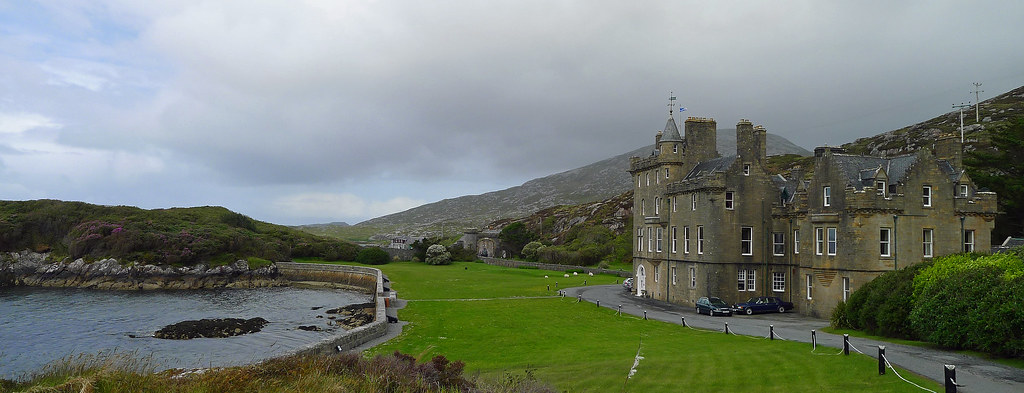
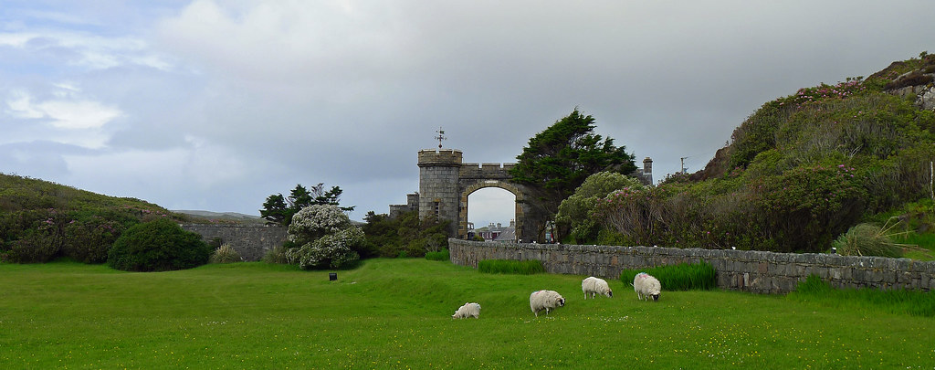
Continuing on, the road mounted a rise, passed through an elaborate set of brick and iron gates, before a brief downhill section rounded a bend and suddenly deposited me into the front garden of Amhuinnsuidhe Castle. Concerned that I had trespassed on someone’s property I quickly checked my map, but I was on the correct route, the B887 road runs right past the front doors of the castle before rounding a bend and continuing west. Passing the castles main doors, I noticed on my left a row of cannons standing guard facing the sea, before all to briefly I was passing through the castles gates. Taken aback by this intriguing scene I doubled back to explore a little more before rounding the end of Loch Leosavay and continuing west towards Huisinis.
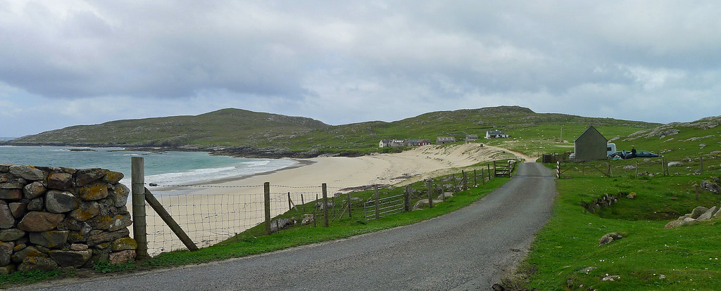
The end of the road brought me to a car park at the east end of the stunning white beach at Huisinis. Huisinis itself was a settlement of only four houses overlooking a white sand beach with views to the Atlantic. Facing me about across the Sound of Scarp was the uninhabited island of Scarp, the location of a failed experimental rocket postal service in the 1930s. The road to Huisinis was home to some magnificent scenery, challenging roads and a few real surprises. I rate it as in the top three roads that I have driven or cycled on, it was that special! Turning around I retraced by route back the way I had come and returned to Tarbert.
Fond memories on the Isle of Harris
That was to be the end of my exploration of Harris. I had spent much more time on the island than I had planned but it was justified as it was the highlight of the trip. My fondest memories from this tour will always be on the Isle of Harris. For the remainder of my holiday I explored the prominent sites on the Isle of Lewis. North Harris and Lewis are part of the same land mass however both are thought of as individual islands. Without question both islands have there own distinctive cultures, religious persuasions, heritage, traditions and landscape. The rugged mountains of North Harris contrasted with the bleak rolling moors and lochans of Lewis.
Leaving Tarbert and heading north towards Lewis it was hilly at first and extremely steep in places especially as I climbed over the Clisham range, which is the highest mountain on the Outer Hebrides standing at nearly 800 metres. Immediately I noticed the increase in traffic, as this road is the main thoroughfare between Harris and Lewis. Compared to the single track roads on the more southerly islands it was a highway, with accompanying semi-trailers that made the narrow, winding and steep descent from the Clisham Range an interesting proposition. In hindsight this road would be best cycled on Sunday when religious observance is strictly adhered to and the traffic consequently light.
Ascending the Clisham range the mountainscape was reminiscent of Norway rather than Scotland and the views at the top were splendid, stretching over towards Rhenigidale and Loch Seaforth, which forms the boundary between North Harris and Lewis. A brief detour east brought me to the tiny settlement of Rhenigidale on the west side of the mouth of Loch Seaforth. This village was once famous for being the most isolated village in the United Kingdom being only accessible by boat or on foot. I had plans to walk the old foot path to Rhenigidale from Tarbert but the weather had other ideas. An interesting walk it would have been as it crosses a col at 250 metres before descending to the shore of Loch Trolamaraig, which it skirts to Rhenigidale. Today however, I traveled the mountainous single track road built in 1989 that now links the once isolated village with the main road between Lewis and Harris. The best part of the road to Rhenigiadale was the descent towards the settlement. The views took in parts of Harris's wild and lonely eastern coastline, but most strikingly extended to the distinctively profiled Shiant Islands. Behind the white cottages of the village that lay scattered above and around a narrow inlet, rose a 528 metre high fin of grey rock know as Todon, while across the valley stood the Crofters Hostel that is popular with cyclists.
Lewis; The Final Isle.
Retracing my route back to the main north-south road the descent off the Clisham Range was narrow, fast and a tad slippery due to the ever present rain. Once past Loch Seaforth the route became easier, as generally Lewis is a vast moorland covered in lochs and peat. My destinations on the Isle of Lewis were to be the Callanish Standing Stones, the Gearrannan Black Houses and Stornoway, the largest town by a country mile on the Outer Hebrides and the departure point for my return to the Scottish mainland and home.
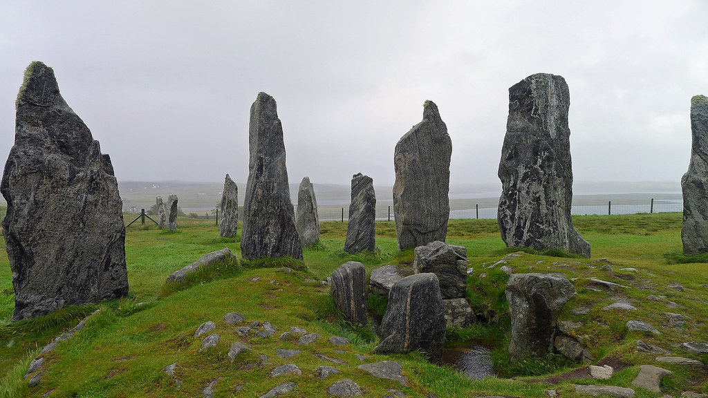
My route to the Callanish Standing Stones took me through the desolate moorlands of Lewis. Never, have I traveled across a landscape that endlessly bleak, so it was with some relief that I arrived in the small village of Callanish. The thought of finding shelter from the relentless wind and rain was appealing but, I was on a mission to find the stone circles. After a few wrong turns I located the Callanish Standing Stones on a wild and secluded promontory overlooking Loch Roagh.
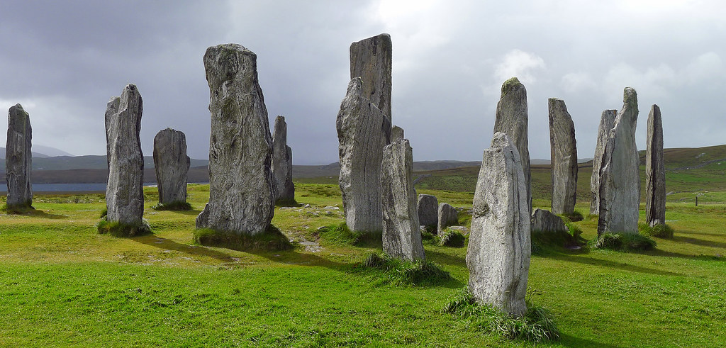
These stones are the most complete stone circles in Great Britain; dating from 3800 to 500 years ago and were the centre of religious activity in the region for an estimated 1500 years. A brief intermission in the horrendous weather allowed some exploring of the site which contained 13 stones of banded gneiss stone arranged around a 4.5m tall central monolith. Some forty smaller stones radiated out from the circle in the shape of a cross with a chambered tomb at its centre. I cannot explain adequately how atmospheric this prehistoric site felt. While the threatening skies added to the mood, the ageless mystery, impressive scale, and undeniable beauty of the site left a lasting impression on me.
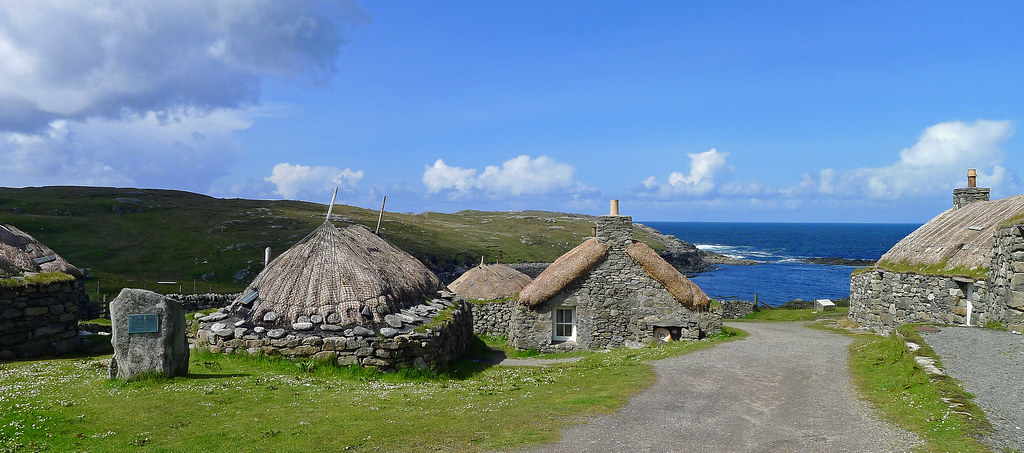
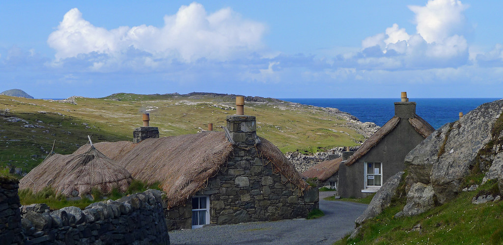
A Blackhouse Village.
My final destination on the Isle of Lewis was the Gearrannan Black House Village, on the exposed Atlantic Coast near the crofting village of Gearrannan. Here, I found nine restored traditional cottages with straw thatched roofs and thick lined walls with an earthen core that must have helped the inhabitants survive the harsh Outer Hebrides environment. It is believed cattle and humans sheltered under the same roof separated at different ends of the structure. The animals have long gone but humans still occupy the houses both as a museum and as quirky holiday homes. Despite their look of real antiquity most of what surrounded me today is believed to be only 150 years old however,the final inhabitants of these blackhouses only moved out in 1974 making them the last group of such houses inhabited in the Western Isles. Located at the end of a single track road facing the village bay and lapped by the waves of the Atlantic, it was an evocative call to the ghosts of a way of life now gone.
Back to the Mainland.
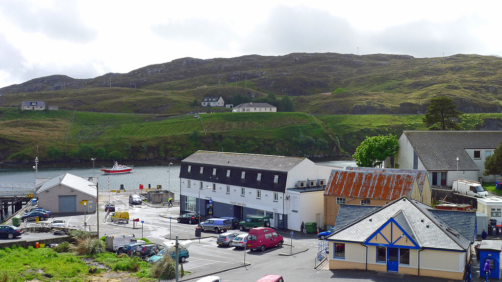
And that all too soon brought to an end my Outer Hebrides cycle tour. The final night I spent in Stornoway a bustling metropolis by Outer Hebridean standards before departing its tranquil harbour early the next morning bound for Ullapool on the Scottish mainland.
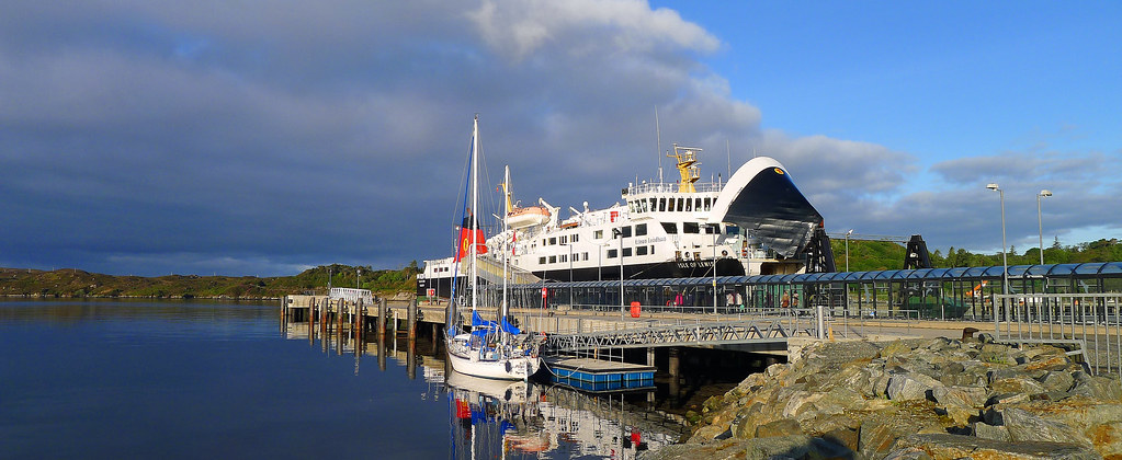
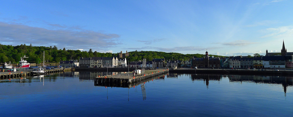
Just under two hours later I was sailing around Ullapool Point and entering Loch Broom where the mountains of the Scottish mainland grabbed my attention. As the MV Isle of Lewis ferry slid into Ullapool Harbour the distinctive spiky little peak of Stac Polliadh, appeared to the north, and I caught a glimpse of Suilven, still further north. To the south the landscape was dominated by the fabled peaks of An Teallach towering above Little Loch Broom. As I left the ferry and strolled down the gangplank I reflected that it was a fitting and memorable finale to my journey.
Subscribe to:
Posts (Atom)