Google+ The Norris Files: June 2012

Pages

Swiss Alpine Route; Schynige Platte - Faulhorn - First - Grindelwald.


I have had these photos from when I visited this part of Switzerland lying around for a few years now, but I had never gotten around to posting them. They were taken with an old cheap camera and I was never overly happy with their quality, nevertheless I decided to tidy them up a little, run them through a slideshow program and compress them into a video. I prefer Vimeo for this process but the compression program did such a poor job that I elected to try YouTube for the first time. The results are definitively better through YouTube and considering the cheap camera used I’m relatively happy with the results.


(Best quality achieved in fullscreen and 1080 HD)

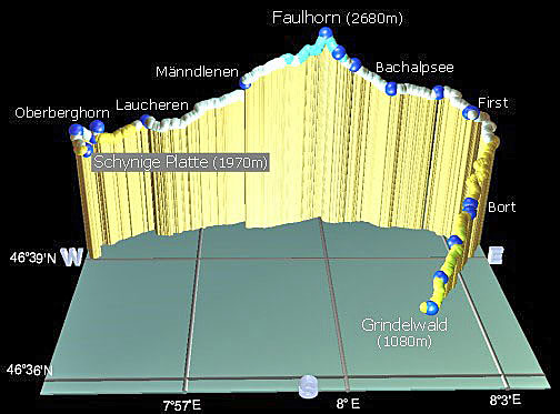
This day walk ranks as one of the most spectacular and scenic hikes in the Bernese Oberland/Jungfrau area, and offers jaw-dropping views in all directions.  It leaves from Schynige Platte at 1969m, ascends to Faulhorn at 2680m and ends at First which is 2180m above sea level. I extended the route to Grindelwald where I was staying which took me back down to an elevation of 1034m. It’s a big day out with at least a kilometre of vertical altitude gained and a similar amount to descent, plus another 1100m if you chose to walk from First down to Grindelwald. The main trail from Schynige Platte to First is 16km but as I continued on to Grindelwald, which I guess added about another ~6-8km or 2-3hrs walking if you take that option (a gondola from First is available, but if you miss the last gondola you have no option but to walk down to Grindelwald).

The start of the walk is reached with a 50 minute trundle on the old and slow cog wheel rack railway which leaves from Wilderswil (586m) and climbs to Schynige Platte, (1967m) home to beautiful green meadows and at the right time of year, masses of alpine flowers. The steep cog railway offers spectacular views of the Brienzersee and the Jungfrau and is a pleasant prelude to the days walk. 

faulhorn3

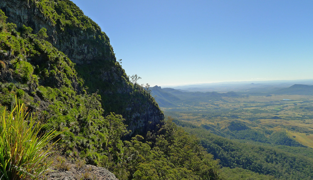
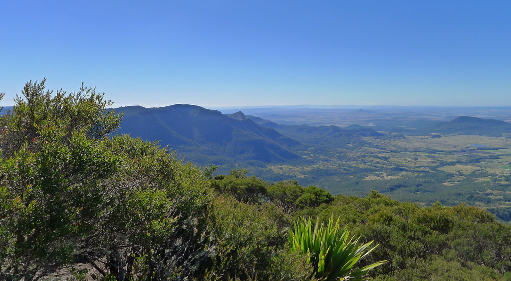
The walk itself is simply stunning, and, has it all! Far below, I was able to peer down on the turquoise waters of the Brienzersee, and the alpine lake of the Thunersee while above, the skyline was dominated by the peaks of the Niesen and the Niederhorn. Below, lay the endless green valleys of Grindelwald and Lauterbrunnen which are surrounded by the majestic towering range of the Wetterhorn, Eiger, Mönch and Jungfrau mountains. Passing wild scree slopes and many beautiful small alpine lakes I descended into a valley in which nestled the not so small but postcard perfect Bachalpsee Lake. From this valley I could see the Rötihorn away to my right while across the lake, the skyline was dominated by the peaks of the Wetterhorn and Schreckhorn.

Mt Cordeaux and Bare Rock Track; Main Range National Park


Mt Cordeaux northern aspect

Cunninghams Gap divides Mt Mitchell from its more northerly neighbouring peak of Mt Cordeaux. From the Gap, the climb to Mt Cordeaux commences from the eastern end of the car park and passes the memorial to Allan Cunningham before climbing to the Mt Cordeaux Lookout. The lookout is located just below the 1135m summit of Mt Coredeaux, on an exposed rocky slab which catches the morning sun. It was one of those beautiful South East Queensland winter mornings, a little chilly in the rainforest sections of the track but once the exposed sections of the track are reached, the winter sun takes the chill from the air.

View south from Mt Cordeaux Lookout

En route to the lookout, on an exposed rock ledge, the head of a mine shaft is located, guarded only by a low chain wire fence. Here, in the early 1900’s, persuaded by a conman with a handful of ‘fools gold’, two local brothers sold their farm and bakery to fund their dream of striking it rich on the mountain. It took years of toil and hardship before they eventually exposed the fraud. It is a sad and permanent reminder of a futile enterprise. 

Mt Cordeaux Lookout provides near 360 degree views; to the north over the ramparts of Mt Castle, east over the scenic rim and further to the sand hills of Stradbroke Island, while to the south, the tip of Mt Warning rises above the Lamington Plateau. Slightly above the lookout the actual summit of Mt Cordeaux rises steeply, (a scramble will get you to the summit but it is not worth it for the views alone as they are superior from the lookout) while below the summit the sheer cliff line is covered with spear lilies’.

View east from Mt Cordeaux Lookout

Leaving Mt Cordeaux Lookout the track heads west on its way to Bare Rock and hugs the southern cliff line of Mt Cordeaux before emerging onto a narrow exposed ledge that links Mt Cordeaux with the rest of the range and offers stunning views back to its summit (This is the access point if you want to scramble off track to the summit). The track then heads uphill through rainforest before finally a brief and simple scramble deposits you onto a wide exposed rock slab that is Bare Rock.

Bare Rock offers similar, near 360 degree views to Mt Cordeaux, perhaps allowing for a little more of the north western aspect however; undoubtedly, it is the best vantage point to view the ramparts of Mt Castle, Boars Head and the razor back ridge that ascends to Mt Castle. Perhaps, later in the day, it may be even be possible to spot the Hole in the Wall, when the sun has dipped below the horizon. My suggestion, would be to save your morning tea or lunch for this spot as the mostly unhindered views are probably only bettered in this region by the completely unhindered views offered from the summit of Mt Maroon. 

Returning to the main track junction I followed the out and back track to Morgans Walk however, this tracks ends abruptly and is mostly overgrown with minimal views in any direction. The 6-7km return journey gave me a chance to get some easy trail running miles into my legs, albeit downhill ones’! A fantastic end to a typically beautiful South East Queensland winter morning!

Mt Mitchell from Mt Cordeaux Lookout

Mt Cordeaux southern aspect

Mt Mitchell and surrounds from Mt Cordeaux Lookout

View southeast from Bare Rock

Mt Mitchell and Cunninghams Gap from Mt Cordeaux Lookout

View to Mt Castle ramparts from Mt Cordeaux Lookout

View from Bare Rock across to Mt Castle

Mt Cordeuax and Bare Rock Track; Main Range National Park